It was early spring when my walking companion and poet Peter Gibbs and I set out on the picturesque forty-six mile long, Llangollen Canal.
This famous waterway, opened in 1805, links Llangollen in North Wales with Hurleston in South Cheshire and had been on our to do list, having passed its junction while walking the Shropshire Union Canal.
The Llangollen Canal was built during the industrial revolution mainly to transport coal from South Denbighshire and to link with the wider canal network via the rivers Mersey, Dee and Severn.
A sulking sun suddenly burst through the clouds early on that dull April morning and all at once the hedgerows were ablaze with a confetti of white blossom, while the wood anemones, primroses and cyclamen scattered along the towpath shone with a brighter hue.
We were now far from the madding crowd enroute for the small northern market town of Whitchurch, some fourteen miles ahead, across a dead flat landscape with the first hints of yellow oil seed rape crops visible in surrounding fields.
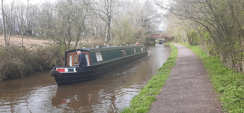
Every now and again a narrowboat puttered by with an exchange of friendly waves.
‘Just walk for another forty minutes and then cross the lift bridge to reach the town,’ instructed a helpful lady in the chanced upon canal side café where we had stopped for tea and cake.
We reached the bridge to find a fingerpost with the single word “town” pointing along a small connecting waterway and our hopes rose that after eight hours on the path, journeys end was at last in sight.
But sadly, it was not to be because the towpath eventually petered out in a small housing estate and we were then led, Siren-like, along a series of linking footpaths to emerge onto a road.
‘Just walk up through the park and you’ll be in the town,’ we were relieved to hear from a passer-by.
After a hearty meal in the friendly Bulls Head and a good night rest in our B&B, our previously flagging spirits revived and we were back on the trail again although the weather had taken a turn for the worse.
Soon we came across West Country couple Joanne, a former carer and her partner Neil, who had acquired their boat Harebelle the previous summer and now planned to spend their future cruising around the country.
Then the rain set in and the towpath, quite uneven in places, soon became slippery and our trusty walking poles came into their own.
Again, our way led through remote open country with only one small village between us and journey’s end in the small market town of Ellesmere, another twelve miles ahead.
Now we entered a large fenland area and nature reserve with small lakes created by old peat diggings and the sounds of wildfowl were soon filling the air.
The waterway was wider here and dead straight for several miles so it was simply a case of putting our hooded heads down and trudging onward.

But then the rain stopped and the canal began meandering across a higher and more wooded landscape and here we came upon a cheery team of Canal and River Trust engineers.
They were busy shoring up a collapsing section of bank, a massive on-going operation when one considers the whole of the waterways network.
Walking on under clearer and more misty skies, we were now enjoying views over two large lakes, which according to our OS map were called “Meres,” hence Ellesmere, we concluded.
Like Whitchurch, this turned out to be a small market town with winding streets and a host of old buildings.
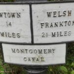
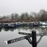
Back on the towpath early the following morning, we soon came upon the junction with the Montgomery Canal, linking with Welshpool and Newtown in mid Wales and another future walk just added itself to the list.
Later the canal began meandering through rolling folds in the landscape with now not so distant Welsh hills encircling the sunny rural scene and a series of locks, not encountered for many a mile, began lifting the canal gently onto higher ground.
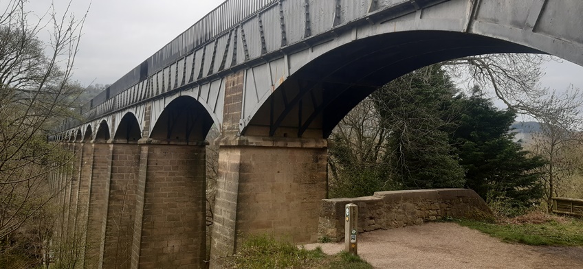
Not far ahead we came upon the impressive seventy foot high and seven-hundred and ten-feet long cast iron Chirk Aqueduct built on stone piers by engineers Thomas Telford and William Jessop to carry the canal across the Ceiriog Valley.
A nose to tail flotilla of narrowboats came towards us, some of which we guessed had over wintered further up the canal and were now migrating to spend the rest of the summer months roaming across the country.
Another treat was in store ahead when we walked through the four-hundred and sixty-yard long Chirk Tunnel guided by a hand rail and a distant dot of light.
Beyond the tunnel, a convenient footpath led us up to a road and into the small town of Chirk and so to that day’s journey’s end and our overnight hotel stopover.
We were back on the towpath by eight am for what promised to be the most scenic and interesting final nine miles of the walk.
A carpet of wood anemones cascaded down through woodland as we approached the much shorter Whitehouse Tunnel and then on to a famous highlight of the walk, namely Telford and Jessop’s spectacular Pontcysyllte Aqueduct.
This spectacular three hundred and thirty-six yards long, one hundred and twenty-six foot high, eighteen arch stone and cast iron triumph of industrial architecture, carries the canal across the River Dee in the Vale of Llangollen.
Soon we were contouring around a wide valley amid high hills with the town of Llangollen and the River Dee far below us en-route for journeys end at the Horseshoe Falls.
But first we had to step aside for a horse- drawn narrowboat packed with tourists. a sight that would have left any time travelling and hardy yesteryear boatman speechless!
NOTE
We stayed overnight at The Premier Inn, Nantwich, Reubens in Whitchurch, The Ellesmere Hotel and finally at The Hand Hotel in Chirk.
While the relevant OS maps are most useful, we find Pearson’s Canal Companions essential when planning all our towpath walks.